


Ahmedabad
(Head Office)Address : 506, 3rd EYE THREE (III), Opp. Induben Khakhrawala, Girish Cold Drink Cross Road, CG Road, Navrangpura, Ahmedabad, 380009.
Mobile : 8469231587 / 9586028957
E-mail: dics.upsc@gmail.com
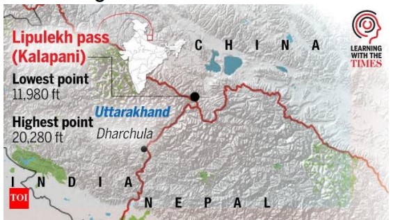
The longstanding territorial dispute over the Kalapani-Limpiyadhura-Lipulekh tri-junction has resurfaced following Nepal formal concerns regarding India planned Kailash Mansarovar Yatra. While Nepal asserts sovereign rights over the region, New Delhi maintains that the claims lack historical evidentiary backing, highlighting a complex diplomatic challenge in South Asia.
• The Core Contention: The dispute centers on the interpretation of the Treaty of Sugauli (1816), specifically the origin of the Kali River. Nepal claims the river originates at Limpiyadhura (further west), making the entire block—including Lipulekh— Nepalese territory. India maintains the river begins at Kalapani, where the river actually takes its name.
• Strategic Significance of Lipulekh: Located at an altitude of over 5,000 meters, the Lipulekh Pass is a vital tri-junction point between India, Nepal, and China. For India, it is geostrategic for monitoring Chinese movements and provides the shortest trekking route for the Kailash Mansarovar Yatra.
• The 2020 Map Controversy: Tensions escalated in 2020 when India inaugurated an 80-km road to Lipulekh. In retaliation, Nepal passed the Constitution (Second Amendment) Act, 2020, updating its national emblem and political map to include the disputed 372 $sq.km$ area, a move India termed an artificial enlargement of claims.
• Diplomatic Protocol Hurdles: Current friction is exacerbated by internal Nepalese politics. Prime Minister Balendra Shah restrictive diplomatic protocols have complicated high-level engagements, potentially shadowing the upcoming visit of Indian Foreign Secretary Vikram Misri.
• Bilateral Mechanism Status: Both nations have established the Boundary Working Group (BWG) to resolve technical issues; however, the Kalapani and Susta segments remain unresolved as they require high-level political intervention rather than purely technical surveying.
Key Definitions
• Cartographic Assertion: The act of using maps to claim sovereignty over a territory, often used as a tool of political signaling in international relations.
• Tri-junction: A geographical point where the boundaries of three countries or sub-national entities meet.
Constitutional & Legal Framework
• Treaty of Sugauli (1816): Signed between the East India Company and the Kingdom of Nepal; it established the Mahakali River as Nepal western boundary but left the river source undefined.
• Article 1 (Nepal Constitution): Defines the territory of Nepal, which was amended in 2020 to include the disputed regions, making the claim a matter of constitutional law in Kathmandu.
• Article 51 (Constitution of India): Promotion of international peace and security, which guides India preference for resolving border disputes through peaceful bilateral dialogue.
Important Key Points
• China Factor: Nepal simultaneous protest to Beijing suggests an attempt to internationalize a bilateral issue, challenging the 2015 India-China agreement to expand border trade through Lipulekh.
• Neighborhood First Policy: The dispute tests India Neighborhood First doctrine, balancing regional hegemony with the sensitivities of a smaller, landlocked sovereign neighbor.
Conclusion:
The Lipulekh issue is a manifestation of cartographic nationalism clashing with established administrative possession. While historical maps are subject to varied interpretations, the resolution lies in revitalizing the Joint Boundary Committee and moving beyond domestic political rhetoric. For India, maintaining the sanctity of the Special Relationship with Nepal is crucial to preventing a strategic vacuum that external powers might exploit.
UPSC Relevance
• GS Paper II: India and its Neighborhood Relations; Bilateral, Regional and Global Groupings and Agreements involving India and/or affecting India’s interests.
• GS Paper III: Border Management; Security challenges and their management in border areas.
• Prelims: Mapping of the Mahakali/Kali River, Lipulekh Pass, and the geography of the Uttarakhand-Nepal border.

Address : 506, 3rd EYE THREE (III), Opp. Induben Khakhrawala, Girish Cold Drink Cross Road, CG Road, Navrangpura, Ahmedabad, 380009.
Mobile : 8469231587 / 9586028957
E-mail: dics.upsc@gmail.com
Address: A-306, The Landmark, Urjanagar-1, Opp. Spicy Street, Kudasan – Por Road, Kudasan, Gandhinagar – 382421
Mobile : 9723832444 / 9723932444
E-mail: dics.gnagar@gmail.com
Address: 2nd Floor, 9 Shivali Society, L&T Circle, opp. Ratri Bazar, Karelibaugh, Vadodara, 390018
Mobile : 9725692037 / 9725692054
E-mail: dics.vadodara@gmail.com
Address: 403, Raj Victoria, Opp. Pal Walkway, Near Galaxy Circle, Pal, Surat-394510
Mobile : 8401031583 / 8401031587
E-mail: dics.surat@gmail.com
Address: 303,305 K 158 Complex Above Magson, Sindhubhavan Road Ahmedabad-380059
Mobile : 9974751177 / 8469231587
E-mail: dicssbr@gmail.com
Address: 57/17, 2nd Floor, Old Rajinder Nagar Market, Bada Bazaar Marg, Delhi-60
Mobile : 9104830862 / 9104830865
E-mail: dics.newdelhi@gmail.com