


Ahmedabad
(Head Office)Address : 506, 3rd EYE THREE (III), Opp. Induben Khakhrawala, Girish Cold Drink Cross Road, CG Road, Navrangpura, Ahmedabad, 380009.
Mobile : 8469231587 / 9586028957
Telephone : 079-40098991
E-mail: dics.upsc@gmail.com
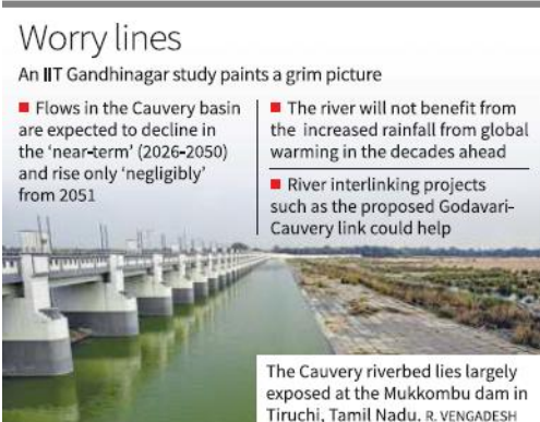
• Projected Near-Term Decline: A study by researchers at IIT Gandhinagar indicates that the Cauvery basin is likely to face a 3.5% reduction in water flow between 2026 and 2050, despite a global warming trend that typically increases river discharge. • Regional Exception: While northern Indian rivers are expected to experience increased flows and potential flooding due to climate change, the Cauvery stands out as a significant geographical exception facing a persistent dry spell. • Historical Context of Depletion: Data analyzed from the Kollegal station reveals that the river already experienced a substantial 28% decline in streamflow during the period between 1951 and 2012. • Methodological Innovation: The research, published in the journal Earth’s Future, utilizes a \'constrained modelling\' approach to reduce errors common in standard climate models, basing projections on actual historical river flow measurements across nine major basins. • Mitigation through Interlinking: Given the historical water-sharing disputes between Karnataka and Tamil Nadu, the study suggests that river interlinking projects, specifically the Godavari-Cauvery link, may become a hydrological necessity to offset the projected deficit. • Climate Paradox: The findings highlight a paradox where increased rainfall projected by global climate models for the Indian subcontinent may not translate into beneficial water gain for the southern peninsular basins. Key Definitions • Streamflow: The volume of water moving through a river channel over a specific period, typically used as a primary indicator of water availability in a basin. • Constrained Modelling: A statistical framework that limits model extrapolations based on realworld historical data (1951–2012) to ensure more geographically accurate climate predictions. • River Interlinking: A civil engineering project aimed at diverting water from \'surplus\' river basins to \'deficit\' basins through a network of reservoirs and canals. Constitutional and Legal Provisions • Article 262: Empowering Parliament to provide for the adjudication of any dispute or complaint with respect to the use, distribution, or control of the waters of any inter-State river or river valley. • Inter-State River Water Disputes Act, 1956: Enacted under Article 262, this law provides the legal machinery (Tribunals) for resolving conflicts like the Cauvery Water Dispute. • Entry 17 (State List): Pertains to water, including water supplies, irrigation, and canals, drainage and embankments, and water storage. • Entry 56 (Union List): Gives the Central Government the power to regulate and develop inter-state rivers and river valleys to the extent declared by Parliament to be expedient in the public interest. Additional Key Points • Socio-Economic Risk: The Cauvery basin is the lifeline for agriculture in the Mandya (Karnataka) and Delta (Tamil Nadu) regions; any decline in flow directly threatens food security and rural livelihoods. • The Godavari-Cauvery Link: Part of the National Perspective Plan (NPP), this project aims to divert surplus water from the Godavari to the Krishna, and then to the Cauvery, acting as a regional insurance against the projected dry spell. • Anthropogenic Factors: Beyond climate change, land-use changes, deforestation in the Western Ghats (the river’s source), and excessive groundwater extraction have historically contributed to the streamflow decline. Conclusion The IIT Gandhinagar study serves as a critical warning for water management in Southern India. As climate change alters traditional hydrological cycles, the \'business-as-usual\' approach to water sharing will likely become untenable. Proactive measures—ranging from the completion of the Godavari-Cauvery interlinking project to the adoption of climate-resilient cropping patterns—are essential to prevent the projected 3.5% decline from escalating into a full-scale regional crisis. UPSC Relevance GS Paper I: Geographical features and their location-changes in critical geographical features (including waterbodies and ice-caps). GS Paper II: Statutory, regulatory and various quasi-judicial bodies; Dispute redressal mechanisms and institutions (Inter-state water disputes). GS Paper III: Conservation, environmental pollution and degradation; Disaster management (droughts); Infrastructure (Water Resources). Prelims: Origin of Cauvery (Talakaveri), major tributaries (Arkavathi, Hemavati, Kabini, Bhavani), and the locations of SPR/Interlinking projects.

Address : 506, 3rd EYE THREE (III), Opp. Induben Khakhrawala, Girish Cold Drink Cross Road, CG Road, Navrangpura, Ahmedabad, 380009.
Mobile : 8469231587 / 9586028957
Telephone : 079-40098991
E-mail: dics.upsc@gmail.com
Address: A-306, The Landmark, Urjanagar-1, Opp. Spicy Street, Kudasan – Por Road, Kudasan, Gandhinagar – 382421
Mobile : 9723832444 / 9723932444
E-mail: dics.gnagar@gmail.com
Address: 2nd Floor, 9 Shivali Society, L&T Circle, opp. Ratri Bazar, Karelibaugh, Vadodara, 390018
Mobile : 9725692037 / 9725692054
E-mail: dics.vadodara@gmail.com
Address: 403, Raj Victoria, Opp. Pal Walkway, Near Galaxy Circle, Pal, Surat-394510
Mobile : 8401031583 / 8401031587
E-mail: dics.surat@gmail.com
Address: 303,305 K 158 Complex Above Magson, Sindhubhavan Road Ahmedabad-380059
Mobile : 9974751177 / 8469231587
E-mail: dicssbr@gmail.com
Address: 57/17, 2nd Floor, Old Rajinder Nagar Market, Bada Bazaar Marg, Delhi-60
Mobile : 9104830862 / 9104830865
E-mail: dics.newdelhi@gmail.com