


Ahmedabad
(Head Office)Address : 506, 3rd EYE THREE (III), Opp. Induben Khakhrawala, Girish Cold Drink Cross Road, CG Road, Navrangpura, Ahmedabad, 380009.
Mobile : 8469231587 / 9586028957
Telephone : 079-40098991
E-mail: dics.upsc@gmail.com
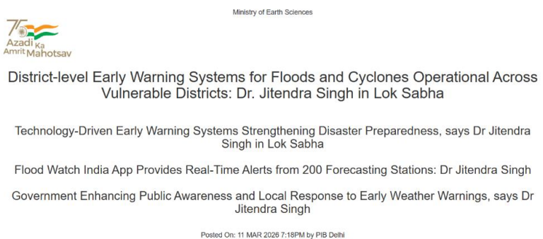
• Operationalizing District-Level EWS: The India Meteorological Department (IMD) now provides district-wise weather updates four times daily, with a seven-day validity. This system focuses on highimpact events like heavy rainfall and cyclones, ensuring that local authorities have actionable data for immediate disaster response. • Nodal Agencies and Flood Forecasting: The Central Water Commission (CWC) serves as the primary agency for flood alerts, operating 350 forecasting stations. This includes 150 inflow stations for dams and 200 level stations for rivers, providing a critical lead time of up to seven days through advanced mathematical modelling. • Granular Monitoring via CFlood & Flood Watch: The \'CFlood\' platform offers villagelevel inundation maps for the Godavari, Tapi, and Mahanadi basins using 2D hydrodynamic modelling. Complementing this, the \'Flood Watch India\' app provides real-time status updates for 500 monitoring stations and 150 reservoirs. • Last-Mile Connectivity and Fishermen Safety: Dissemination is streamlined through the Common Alerting Protocol (CAP) and the NAVIC satellite system. Special provisions for deep-sea fishermen include alerts via INCOIS and All India Radio, ensuring no \'communication dark zones\' during maritime emergencies. • Institutional Synergy: The system integrates central agencies (IMD, CWC, INCOIS) with State Disaster Management Authorities (SDMAs). Warnings are channeled through State Emergency Operation Centres (SEOCs) to local sirens and mobile alerts, creating an end-to-end disaster communication loop. • Financial Backing for Mitigation: Strengthening of EWS infrastructure is funded through the State Disaster Response Fund (SDRF) and State Disaster Mitigation Fund (SDMF), with additional support from national-level funds (NDRF/NDMF) based on gravity and requirements. Key Definitions and Digital Platforms • Common Alerting Protocol (CAP): An international standard format for emergency alerts and public warnings, designed for \'all-hazards\' over all types of networks. • Inundation Forecasting: The process of predicting the extent, depth, and duration of flooding in a specific area, often visualized through color-coded maps (Red, Orange, Yellow). • Quantitative Precipitation Forecast (QPF): A technical estimate of the amount of liquid precipitation expected to fall in a specified area over a set period. • NAVIC (Navigation with Indian Constellation): India\'s autonomous regional satellite navigation system, used here for transmitting emergency messages to fishermen beyond the range of terrestrial mobile networks. Constitutional and Legal Provisions • Disaster Management Act, 2005: The primary legal framework that mandates the creation of the NDMA (National) and SDMAs (State). It provides the statutory basis for the \'National Policy on Disaster Management.\' • Article 21 (Right to Life): The Supreme Court has interpreted the right to a safe environment and protection from man-made/preventable disasters as an extension of the Fundamental Right to Life. • Entry 23, List III (Concurrent List): \'Social security and social insurance; employment and unemployment,\' often used in the context of disaster relief, though Disaster Management as a specific subject is handled through the residuary powers of the Union and coordinated federalism. Conclusion The shift from a \'reactive\' to a \'proactive\' disaster management paradigm is evident in the deployment of highresolution tools like C-Flood and NAVIC-linked alerts. By bridging the gap between scientific data and locallevel dissemination, India is moving toward a \'Zero Casualty\' goal for recurring natural hazards. The success of these systems, however, depends on the continuous technological upgrading of last-mile infrastructure and sustained community awareness programs. UPSC Relevance • General Studies I: Important Geophysical phenomena such as cyclones and floods; Geographical features and their location-changes in critical geographical features. • General Studies III: Disaster and disaster management; Role of external state and non-state actors in creating challenges to internal security (infrastructure security); Science and Technology- developments and their applications and effects in everyday life. • Prelims: Nodal agencies for various disasters (CWC for floods, IMD for cyclones), Satellite systems (NAVIC), and various disaster-related funds (SDRF/NDRF).

Address : 506, 3rd EYE THREE (III), Opp. Induben Khakhrawala, Girish Cold Drink Cross Road, CG Road, Navrangpura, Ahmedabad, 380009.
Mobile : 8469231587 / 9586028957
Telephone : 079-40098991
E-mail: dics.upsc@gmail.com
Address: A-306, The Landmark, Urjanagar-1, Opp. Spicy Street, Kudasan – Por Road, Kudasan, Gandhinagar – 382421
Mobile : 9723832444 / 9723932444
E-mail: dics.gnagar@gmail.com
Address: 2nd Floor, 9 Shivali Society, L&T Circle, opp. Ratri Bazar, Karelibaugh, Vadodara, 390018
Mobile : 9725692037 / 9725692054
E-mail: dics.vadodara@gmail.com
Address: 403, Raj Victoria, Opp. Pal Walkway, Near Galaxy Circle, Pal, Surat-394510
Mobile : 8401031583 / 8401031587
E-mail: dics.surat@gmail.com
Address: 303,305 K 158 Complex Above Magson, Sindhubhavan Road Ahmedabad-380059
Mobile : 9974751177 / 8469231587
E-mail: dicssbr@gmail.com
Address: 57/17, 2nd Floor, Old Rajinder Nagar Market, Bada Bazaar Marg, Delhi-60
Mobile : 9104830862 / 9104830865
E-mail: dics.newdelhi@gmail.com