


Ahmedabad
(Head Office)Address : 506, 3rd EYE THREE (III), Opp. Induben Khakhrawala, Girish Cold Drink Cross Road, CG Road, Navrangpura, Ahmedabad, 380009.
Mobile : 8469231587 / 9586028957
E-mail: dics.upsc@gmail.com

Key Highlights & Summary
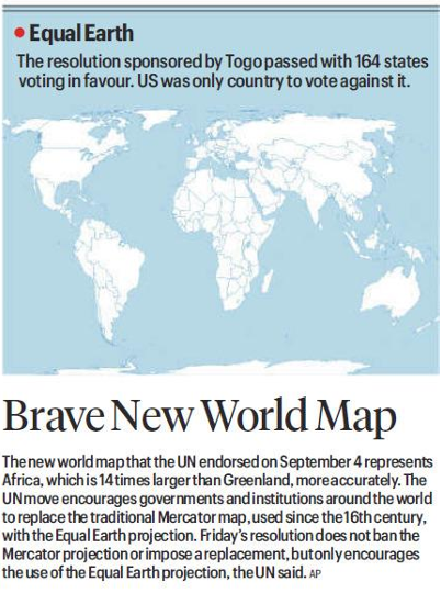
• UN Endorsement: The United Nations endorsed the \'Equal Earth\' map projection on September 4 to represent global landmasses, particularly Africa, more accurately.
• Resolution Sponsored by Togo: The resolution, sponsored by Togo, passed with 164 member states voting in favor, with the United States being the sole country voting against it.
• Addressing Map Distortion: The initiative targets the centuries-old Mercator projection, which severely exaggerates land sizes near the poles while shrinking tropical landmasses like Africa (which is actually 14 times larger than Greenland).
• Voluntary Transition: The resolution does not ban the Mercator projection or legally impose a replacement, but actively encourages governments and international institutions to adopt the Equal Earth map.
• Historical Context: The traditional Mercator map has been in widespread global use since the 16th century, primarily designed for maritime navigation rather than relative land area representation.
• Cartographic Equity: Adoption of an equal-area projection seeks to rectify Eurocentric spatial bias and present an accurate geographic proportion in education and policy.
Essential Definitions
• Equal Earth Projection: An equal-area pseudocylindrical map projection created in 2018 that visually presents landmasses in relative proportion to their true surface area while maintaining an aesthetically pleasing shape.
• Mercator Projection: A conformal cylindrical map projection created by Gerardus Mercator in 1569 that preserves local angles and shapes for navigation but drastically inflates the size of objects as latitude increases toward the poles.
Legal and Constitutional Framework
• UN General Assembly Rules of Procedure: Governs voting mechanisms for non-binding recommendations aimed at international cooperation in educational and cultural spheres under Article 13 of the UN Charter.
• Article 51 of the Indian Constitution: Directs the State to foster respect for international law, treaty obligations, and international organizations like the United Nations.
• Survey of India Policy Guidelines: Regulates official map production and cartographic standards within India under the National Map Policy.
Conclusion The UN endorsement of the Equal Earth projection marks a significant shift toward cartographic fairness and geographical accuracy. Replacing skewed colonial-era projections helps foster an unbiased global perspective across educational curricula and international relations.
UPSC Relevance
• GS Paper I (Geography): Cartography, map projections (Mercator vs. Equal Area), spatial distortion, and geographic representations of global landmasses.
• GS Paper II (International Relations): UN General Assembly resolutions, multilateral diplomacy, institutional reforms, and global soft-power dynamics.


Address : 506, 3rd EYE THREE (III), Opp. Induben Khakhrawala, Girish Cold Drink Cross Road, CG Road, Navrangpura, Ahmedabad, 380009.
Mobile : 8469231587 / 9586028957
E-mail: dics.upsc@gmail.com
Address: A-306, The Landmark, Urjanagar-1, Opp. Spicy Street, Kudasan – Por Road, Kudasan, Gandhinagar – 382421
Mobile : 9723832444 / 9723932444
E-mail: dics.gnagar@gmail.com
Address: 2nd Floor, 9 Shivali Society, L&T Circle, opp. Ratri Bazar, Karelibaugh, Vadodara, 390018
Mobile : 9725692037 / 9725692054
E-mail: dics.vadodara@gmail.com
Address: 403, Raj Victoria, Opp. Pal Walkway, Near Galaxy Circle, Pal, Surat-394510
Mobile : 8401031583 / 8401031587
E-mail: dics.surat@gmail.com
Address: 303,305 K 158 Complex Above Magson, Sindhubhavan Road Ahmedabad-380059
Mobile : 9974751177 / 8469231587
E-mail: dicssbr@gmail.com
Address: 57/17, 2nd Floor, Old Rajinder Nagar Market, Bada Bazaar Marg, Delhi-60
Mobile : 9104830862 / 9104830865
E-mail: dics.newdelhi@gmail.com