


Ahmedabad
(Head Office)Address : 506, 3rd EYE THREE (III), Opp. Induben Khakhrawala, Girish Cold Drink Cross Road, CG Road, Navrangpura, Ahmedabad, 380009.
Mobile : 8469231587 / 9586028957
Telephone : 079-40098991
E-mail: dics.upsc@gmail.com
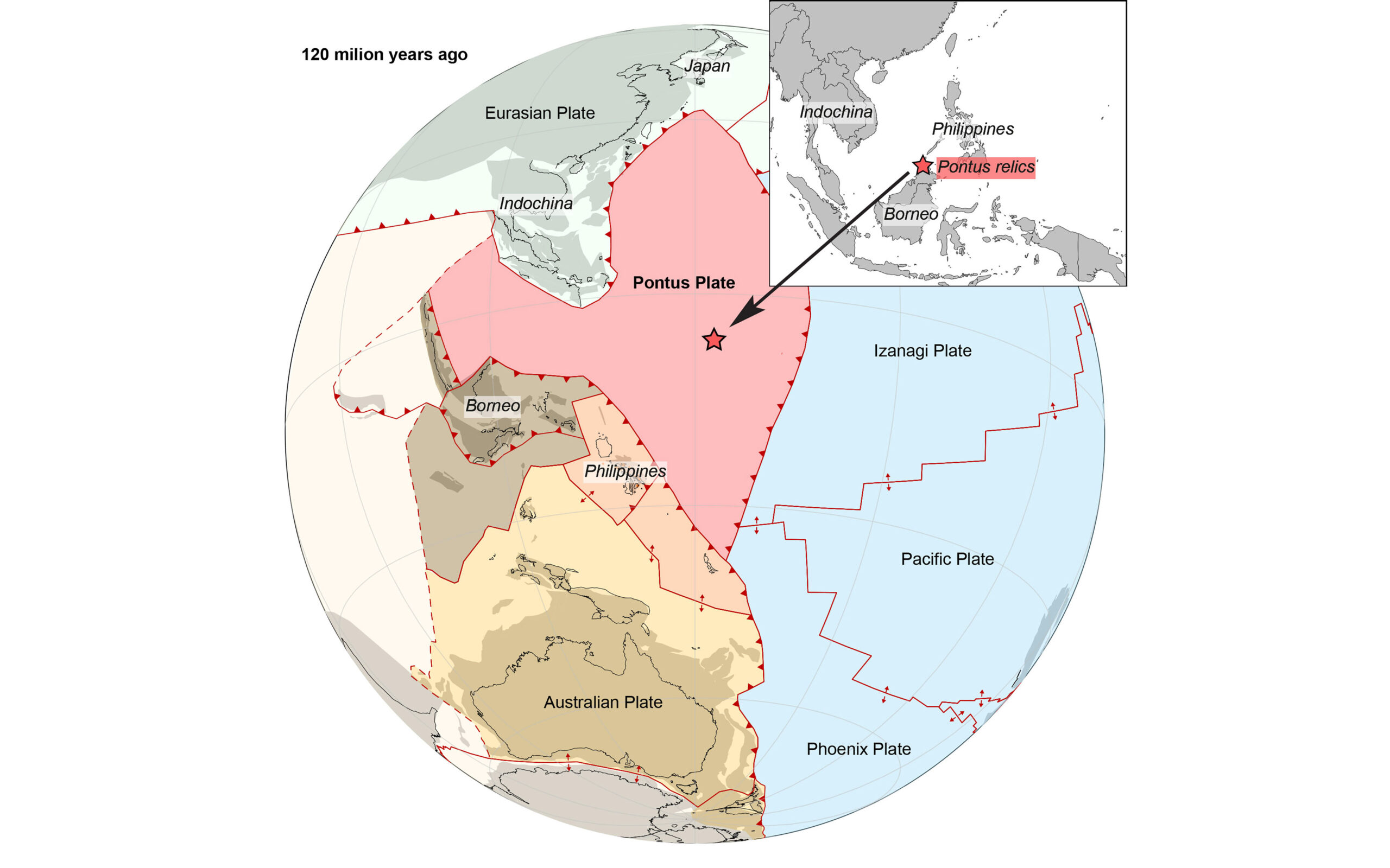
Pontus Plate
News: Scientists discover a long-lost tectonic plate 'Pontus', an ancient mega-plate that disappeared 20 million years ago.
About:
• The Pontus plate is a long-lost tectonic plate that disappeared about 20 million years ago. This plate was approximately a quarter the size of the Pacific Ocean and once existed beneath an ancient ocean known as the Pontus Ocean.
• The rediscovery of the Pontus plate was accidental, occurring during a study of rocks in Borneo. Researchers had originally been studying the Pacific plate when they came across rock fragments that didn’t fit with known plates’ magnetic properties.
• Computer modelling eventually revealed that these rock fragments belonged to a previously unknown tectonic plate, the Pontus plate. This plate formed at least 160 million years ago, possibly even earlier, and eventually disappeared as it was subducted beneath the Australian and Chinese plates. This discovery sheds light on Earth’s geological history and the movement of tectonic plates.
What is Subduction?
• Subduction is the geologic process in which one edge of one lithospheric plate is forced below the edge of another – and over time an entire plate can be lost.
• Crucially, a subducted plate leaves behind traces when it 'sinks' into Earth's mantle – namely, fragments of rock hidden in mountain belts. It is an ongoing process.
What are Tectonic plates?
• A tectonic plate, also called a lithospheric plate, is a massive, irregularly shaped slab of solid rock, generally composed of both continental and oceanic lithosphere. The plates are around 100 km (62 mi) thick and consist of two principal types of material: oceanic crust (also called sima from silicon and magnesium) and continental crust (sial from silicon and aluminium).
• These plates lie on top of a partially molten layer of rock called the asthenosphere. Due to the convection of the asthenosphere and lithosphere, the plates move relative to each other at different rates, from two to 15 centimeters (one to six inches) per year.
• When these plates meet, their relative motion determines the type of boundary: convergent, divergent, or transform. These boundaries are responsible for many different geological formations such as the Himalaya mountain range in Asia, the East African Rift, and the San Andreas Fault in California, United States.
• They also cause earthquakes, volcanism, and induce the recycling of elements within the biosphere and between the geosphere and biosphere.
Types of Boundaries:
• Convergent Boundaries: These occur where plates are colliding. There are three types of convergent boundaries:
• Geological Formations - Deep ocean trenches, Volcanoes, Island arcs, Submarine mountain ranges, Fault lines and Mountains, volcanic islands, and trenches
o Oceanic vs. Continental: The denser oceanic plate is forced under the lighter continental plate, creating mountains, a trench, and leading to volcanic activity.
o Oceanic vs. Oceanic: When two oceanic plates collide, the older denser plate subducts or “dives” underneath the other plate, forming a deep trench on the seafloor and leading to undersea volcanic activity.
o Continental vs. Continental: When continental plates collide into one another, neither plate can subduct under the other because they are equally light and buoyant. Instead, they are pressed
together under intense pressure, causing the earth’s surface to develop folds and faults, often
leading to the development of mountain ranges. Example – Himalayan mountains
Divergent Boundaries: These represent areas where plates are spreading apart or separating from one another. This spreading is caused by convective forces in the molten magma below them. When this occurs between two oceanic plates, as they slowly spread apart, this fluid basalt lava fills the gap and quickly solidifies as the water cools it, forming new oceanic crust.
o Geological Formations - A submarine mountain range such as the Mid-Atlantic Ridge, Volcanic activity in the form of fissure eruptions, Shallow earthquake activity, Creation of new seafloor and a widening ocean basin and Long mountain ranges and intervening valleys (basins) on continental crust.
Transform Boundaries: These occur where plates are sliding past each other. Rocks that line the boundary are pulverized as the plates grind along, creating a linear fault valley or undersea canyon. Earthquakes are common along these faults.
o Geological Formations – Linear Valleys, small ponds, Deep trenches, Scarps and Ridges.

Address : 506, 3rd EYE THREE (III), Opp. Induben Khakhrawala, Girish Cold Drink Cross Road, CG Road, Navrangpura, Ahmedabad, 380009.
Mobile : 8469231587 / 9586028957
Telephone : 079-40098991
E-mail: dics.upsc@gmail.com
Address: A-306, The Landmark, Urjanagar-1, Opp. Spicy Street, Kudasan – Por Road, Kudasan, Gandhinagar – 382421
Mobile : 9723832444 / 9723932444
E-mail: dics.gnagar@gmail.com
Address: 2nd Floor, 9 Shivali Society, L&T Circle, opp. Ratri Bazar, Karelibaugh, Vadodara, 390018
Mobile : 9725692037 / 9725692054
E-mail: dics.vadodara@gmail.com
Address: 403, Raj Victoria, Opp. Pal Walkway, Near Galaxy Circle, Pal, Surat-394510
Mobile : 8401031583 / 8401031587
E-mail: dics.surat@gmail.com
Address: 303,305 K 158 Complex Above Magson, Sindhubhavan Road Ahmedabad-380059
Mobile : 9974751177 / 8469231587
E-mail: dicssbr@gmail.com
Address: 57/17, 2nd Floor, Old Rajinder Nagar Market, Bada Bazaar Marg, Delhi-60
Mobile : 9104830862 / 9104830865
E-mail: dics.newdelhi@gmail.com