


Ahmedabad
(Head Office)Address : 506, 3rd EYE THREE (III), Opp. Induben Khakhrawala, Girish Cold Drink Cross Road, CG Road, Navrangpura, Ahmedabad, 380009.
Mobile : 8469231587 / 9586028957
Telephone : 079-40098991
E-mail: dics.upsc@gmail.com
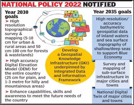
National Geospatial Policy 2022
News: After liberalizing the use of geospatial data under the draft geospatial data policy in February 2021, the Ministry of Science and Technology has notified the National Geospatial Policy, 2022.
What are the details about the policy?
• The National Geospatial Policy, 2022 is a citizen-centric policy that seeks to strengthen the geospatial sector to support national development, economic prosperity and a thriving information economy
• The 13-year guideline promote the country’s geospatial data industry and develops a national framework to use such data for improving citizen services, and more.
• The policy has divided 14 Geospatial Data Themes to support the development of commercial geospatial applications in various sectors such as disaster management, mining, forestry etc.
What kind of infrastructure the government intends to build?
• Geospatial Knowledge Infrastructure (GKI):
o The government will establish an Integrated Data and Information Framework by 2030 (to develop GKI)
o The government will also establish National Digital Twin (for high-resolution topographical survey and mapping by 2035)
• Institutional Infrastructure:
o Geospatial Data Promotion and Development Committee(‘GDPDC’) will be constituted for formulating and implementing guidelines, strategies, and programs for the promotion of activities related to the Geospatial sector.
o Will put in place a legal framework (by 2025) that supports the liberalization of the geospatial sector, and democratization of data for enhanced commercialization with value-added services.
Importance of the Policy:
• Government has opened its geospatial data and services offered by government agencies, academic and research institutions, private organizations, NGOs, and individuals.
• Government has removed the requirement for prior approval, security clearance, or other restrictions on the management of geospatial data. Self-Certification will be sufficient for adherence to the guidance
• Anyone can process the acquired geospatial data, build new applications and solutions using it and use it for profit (except for defence or security-related data)
• The Policy recognizes the importance of locally available and locally relevant Maps and Geospatial Data
• By 2035, the policy will include mapping of sub-surface infrastructure in major cities and towns across India, and the development of accurate bathymetric geospatial data (resources and economy of inland waters, and sea surface topography of shallow and deep seas)
• The Policy enables and supports innovation, creation and incubation of ideas and start-up initiatives in the Geospatial sector.
How will the Geospatial policy potentially help?
• It will enhance private participation in agri-tech industry. For example, it will widen the scope and adoption of precision farming.
• While the global positioning system (GPS) locates precise crop locations, the global information system (GIS) stores this data. This data later helps in Crop scouting, Soil sampling, weed location, accurate planting, and harvesting.
• Along with the SWAMITVA scheme, the geospatial data will help in the pooling of lands by farmers. This will drive wider adoption of Commercial and Precision Farming in India.
• Better implementation of Government schemes such as PM Fasal Bima Yojana, Soil health card schemes and ‘Per Drop more Crop’. Geospatial data will assist the BFSI segment to understand the risk better and underwrite loans and insurance products.
• Better geospatial data will drive more targeted and deeper fishing opportunities, thus helping in the economic upliftment of fishermen. It will help bridge the infrastructure gap as envisaged under PM Matsya Sampada Yojana.
• The flagship schemes of the Government like the Gati Shakti program can be smoothly implemented using geospatial technology. The scheme involves huge investments in construction of about 25,000 Kms of highways, multimodal transport, and modernization of land records.
• Focusing on the sector will allow Indian companies to develop indigenous apps like an Indian version of google maps.
• Using this technology, the data related large number of landholdings can be appropriately tagged and digitized. It will not only help in better targeting but would also reduce the quantum of land disputes in courts.
Way Forward:
• Geospatial will be a crucial technology that will drive growth ambitions of the country – providing employment and also aiding the new-age ecosystem by providing location intelligence at your fingertips. More and more sectors such as agriculture, environment protection, power, water, transportation, health etc. desire the technology in order to realize their potential.

Address : 506, 3rd EYE THREE (III), Opp. Induben Khakhrawala, Girish Cold Drink Cross Road, CG Road, Navrangpura, Ahmedabad, 380009.
Mobile : 8469231587 / 9586028957
Telephone : 079-40098991
E-mail: dics.upsc@gmail.com
Address: A-306, The Landmark, Urjanagar-1, Opp. Spicy Street, Kudasan – Por Road, Kudasan, Gandhinagar – 382421
Mobile : 9723832444 / 9723932444
E-mail: dics.gnagar@gmail.com
Address: 2nd Floor, 9 Shivali Society, L&T Circle, opp. Ratri Bazar, Karelibaugh, Vadodara, 390018
Mobile : 9725692037 / 9725692054
E-mail: dics.vadodara@gmail.com
Address: 403, Raj Victoria, Opp. Pal Walkway, Near Galaxy Circle, Pal, Surat-394510
Mobile : 8401031583 / 8401031587
E-mail: dics.surat@gmail.com
Address: 303,305 K 158 Complex Above Magson, Sindhubhavan Road Ahmedabad-380059
Mobile : 9974751177 / 8469231587
E-mail: dicssbr@gmail.com
Address: 57/17, 2nd Floor, Old Rajinder Nagar Market, Bada Bazaar Marg, Delhi-60
Mobile : 9104830862 / 9104830865
E-mail: dics.newdelhi@gmail.com