
Ahmedabad
(Head Office)Address : 506, 3rd EYE THREE (III), Opp. Induben Khakhrawala, Girish Cold Drink Cross Road, CG Road, Navrangpura, Ahmedabad, 380009.
Mobile : 8469231587 / 9586028957
E-mail: dics.upsc@gmail.com
Ken-Betwa Interlinking Project
News: The Union Cabinet has approved the funding and implementation of the Ken-Betwa river interlinking project at the 2020-21 price level.
Ken-Betwa Interlinking Project
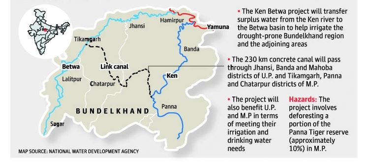
• The Ken-Betwa Link Project is the first project under the National Perspective Plan for the interlinking of rivers.
• Under this project, water from the Ken River will be transferred to the Betwa River. Both these rivers are tributaries of the river Yamuna.
• The project is being managed by India’s National Water Development Agency (NWDA), under the Ministry of Jal Shakti.
• Implementation of the project includes two phases:
o Phase-I: Daudhan dam complex and its appurtenances like Low Level Tunnel, High Level Tunnel, Ken-Betwa link canal and Power houses
o Phase-II: Lower Orr dam, Bina complex project and Kotha Barrage
Significance:
• The project is slated to irrigate 10.62 lakh hectares annually, provide drinking water supply to 62 lakh people and generate 103 MW of hydropower and 27 MW of solar power.The project will be of immense benefit to the water-starved Bundelkhand region, spread across Madhya Pradesh and Uttar Pradesh.
• The project is expected to boost socio-economic prosperity in the backward Bundelkhand region on account of increased agricultural activities and employment generation.
• It would also help in arresting distress migration from this region.
Challenges:
• The project will partly submerge the Panna Tiger Reserve in Madhya Pradesh and affect the habitat of vultures and jackals.After years of protests, it was finally cleared by the apex wildlife regulator, the National Board for Wildlife, in 2016.
• Then UP and MP could not agree on how water would be shared, particularly in the non-monsoonal months.
River Interlinking in India
Background:
• The idea of interlinking of rivers in the Indian subcontinent is at least 150 years old.During the British Raj in India, Sir Arthur Cotton, a British general and irrigation engineer, first suggested linking the Ganga and the Cauvery for navigational purposes.
• K.L. Rao’s Proposal (1972), which had 2640 km long Ganga – Cauvery link as its main component involved large scale pumping over a head of 550 m.The Central Water Commission, which examined the proposal, found it to be grossly under estimated and economically prohibitive.
• Capt. Dastur Proposal (1977) envisaged the construction of two canals:
o 4200 km Himalayan Canal at the foot of Himalayan slopes running from the Ravi in the West to the Brahmaputra and beyond in the east
o 9300 km Garland Canal covering the central and southern parts
Implementation:
• The Indian Rivers Inter-link aims to link India’s rivers by a network of reservoirs and canals and so reduce persistent floods in some parts and water shortages in other parts of India.
• The idea to link rivers got a shot in the arm with the establishment of the National Water Development Agency in 1982 by then PM Indira Gandhi.The Inter-link project was split into three parts:
o Northern Himalayan rivers inter-link component
o Southern Peninsular component
o Intrastate rivers linking component
Objectives:
• Connect the Himalayan and peninsular rivers via a network of canals so that
• Excess water from one channel can be diverted to another which has an inadequate flow
• Flood moderation in the Ganga-Brahmaputra system
• Hydropower generation through excess water
Challenges:
• This is one of the most daring feats of engineering attempted in the history of mankind.
• It is a reimagining of the entire aquatic ecosystem of a country as large and diverse as India.
Advantages:
• Problems related to flood control, irrigation, limiting droughts and boosting farm output—can be sorted out by linking the country’s rivers.
• Potential benefits to transport infrastructure through navigation, as well as to broadening income sources in rural areas through fish farming.
Issues:
• It will lead to massive displacement of people
• Since the Ganga basin topography is flat, building dams would not substantially add to river flows.
• The transfer of such enormous amounts of water will inundate forests and land for reservoirs.
• The weight of billions of liters of water can have seismic implications in the Himalayan region.
• River inter-linking is an expensive business from building the link canals to the monitoring and maintenance infrastructure.
• Implementation of the project not only needs a huge financial capital but also political support both is scarce commodities as of now.
• Another important issue is building consensus among states and Land acquisition.
• Once the project is implemented it would lead to large-scale displacement of people and animals.

Address : 506, 3rd EYE THREE (III), Opp. Induben Khakhrawala, Girish Cold Drink Cross Road, CG Road, Navrangpura, Ahmedabad, 380009.
Mobile : 8469231587 / 9586028957
E-mail: dics.upsc@gmail.com
Address: A-306, The Landmark, Urjanagar-1, Opp. Spicy Street, Kudasan – Por Road, Kudasan, Gandhinagar – 382421
Mobile : 9723832444 / 9723932444
E-mail: dics.gnagar@gmail.com
Address: 2nd Floor, 9 Shivali Society, L&T Circle, opp. Ratri Bazar, Karelibaugh, Vadodara, 390018
Mobile : 9725692037 / 9725692054
E-mail: dics.vadodara@gmail.com
Address: 403, Raj Victoria, Opp. Pal Walkway, Near Galaxy Circle, Pal, Surat-394510
Mobile : 8401031583 / 8401031587
E-mail: dics.surat@gmail.com
Address: 303,305 K 158 Complex Above Magson, Sindhubhavan Road Ahmedabad-380059
Mobile : 9974751177 / 8469231587
E-mail: dicssbr@gmail.com
Address: 57/17, 2nd Floor, Old Rajinder Nagar Market, Bada Bazaar Marg, Delhi-60
Mobile : 9104830862 / 9104830865
E-mail: dics.newdelhi@gmail.com