


Ahmedabad
(Head Office)Address : 506, 3rd EYE THREE (III), Opp. Induben Khakhrawala, Girish Cold Drink Cross Road, CG Road, Navrangpura, Ahmedabad, 380009.
Mobile : 8469231587 / 9586028957
E-mail: dics.upsc@gmail.com
International Maritime Boundary Line
News: The Tamil Nadu police have issued an alert on the possibility of an attack on fishermen crossing the International Maritime Boundary Line (IMBL) for fishing in Sri Lankan waters.
About International Maritime Boundary Line (IMBL)
• A maritime boundary is a conceptual division of the Earth’s water surface areas using physiographic or geopolitical criteria.
• As such, it usually bounds areas of exclusive national rights over mineral and biological resources, encompassing maritime features, limits and zones.
• Generally, a maritime boundary is delineated at a particular distance from a jurisdiction’s coastline.
• Although in some countries the term maritime boundary represents borders of a maritime nation that are recognized by the United Nations Convention on the Law of the Sea.
• The terminology does not encompass lake or river boundaries, which are considered within the context of land boundaries.
• The delineation of maritime boundaries has strategic, economic, and environmental implications.
• Maritime spaces can be divided into the following groups based on their legal status:
• Under the sovereignty and authority (exercising power) of a coastal State: internal waters, territorial sea, and archipelagic waters,
• With mixed legal regime, which fall under both the jurisdiction of the coastal State and under the international law: contiguous zone, the continental shelf and the exclusive economic zone, and
• That can be used by all States (including land-locked ones) on an equal basis: high seas.
• While many maritime spaces can be classified as belonging to the same group, this does not imply that they all have the same legal regime. International straits and canals have their own legal status as well.
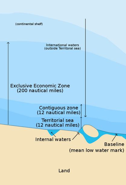
Zones
• The zones of maritime boundaries are expressed in concentric limits surrounding coastal and feature baselines.
• Inland waters—the zone inside the baseline.
• Territorial sea—the zone extending 12 nm. from the baseline
• Contiguous zone—the area extending 24 nm. from the baseline
• Exclusive Economic Zone—the area extending 200 nm from the baseline except when the space between two countries is less than 400 nm

Address : 506, 3rd EYE THREE (III), Opp. Induben Khakhrawala, Girish Cold Drink Cross Road, CG Road, Navrangpura, Ahmedabad, 380009.
Mobile : 8469231587 / 9586028957
E-mail: dics.upsc@gmail.com
Address: A-306, The Landmark, Urjanagar-1, Opp. Spicy Street, Kudasan – Por Road, Kudasan, Gandhinagar – 382421
Mobile : 9723832444 / 9723932444
E-mail: dics.gnagar@gmail.com
Address: 2nd Floor, 9 Shivali Society, L&T Circle, opp. Ratri Bazar, Karelibaugh, Vadodara, 390018
Mobile : 9725692037 / 9725692054
E-mail: dics.vadodara@gmail.com
Address: 403, Raj Victoria, Opp. Pal Walkway, Near Galaxy Circle, Pal, Surat-394510
Mobile : 8401031583 / 8401031587
E-mail: dics.surat@gmail.com
Address: 303,305 K 158 Complex Above Magson, Sindhubhavan Road Ahmedabad-380059
Mobile : 9974751177 / 8469231587
E-mail: dicssbr@gmail.com
Address: 57/17, 2nd Floor, Old Rajinder Nagar Market, Bada Bazaar Marg, Delhi-60
Mobile : 9104830862 / 9104830865
E-mail: dics.newdelhi@gmail.com