


Ahmedabad
(Head Office)Address : 506, 3rd EYE THREE (III), Opp. Induben Khakhrawala, Girish Cold Drink Cross Road, CG Road, Navrangpura, Ahmedabad, 380009.
Mobile : 8469231587 / 9586028957
E-mail: dics.upsc@gmail.com
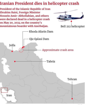
News: As part of a multi-agency effort to locate a helicopter carrying Iranian President that crashed in East Azerbaijan province, European Union activated its emergency satellite mapping service
• Launched in 1998 and previously known as the Global Monitoring for Environment and Security Programme (GMES), Copernicus is the earth observation component of the European Union’s space programmed.
• The programme is named after Nicolaus Copernicus, the 15th-century Polish scientist who first proposed a heliocentric universe model.
• The programme uses global data from satellites, and ground-based, airborne, and sea-borne measurement systems to address issues related to climate change, disaster management, agriculture, etc.
• The space segment uses a group of satellites called the Sentinels and the Contributing Missions. It is complemented by a ground segment that includes in-situ sensors that provide access to the Sentinels and Contributing Missions data.
• The programmed is implemented by EU member states with the support of the European Space Agency for the space component and the European Environment Agency (EEA) for the in-situ component.
• Data from the Copernicus programme is freely available and accessible to all
• The rapid response mapping technology is a critical component of the Emergency Management Service (EMS) within the Copernicus programme.
• Active since 2012, the Copernicus Emergency Management Service (CEMS) works on two models — ondemand mapping and early warning and monitoring — to issue warnings, risk assessments and information on the impact of disasters worldwide, before, during, or after a crisis.
• While on-demand mapping offers detailed information for specific emergencies, early warning provides critical geospatial data through monitoring and forecasts for floods, droughts, and forest fires.
• The Copernicus EMS on-demand rapid mapping provides geospatial information within a few hours or days of a request to support efforts in the immediate aftermath of an emergency or a disaster anywhere in the world.
• It acquires, processes, and analyses satellite images, geospatial data, and relevant social media in rapid mode to provide information.
• The service offers four products — one pre-event reference and three postevent (first estimate, delineation, grading).
• First Estimate Product offers a fast but rough assessment of the most affected area using the earliest post-event image.
• Delineation assesses the extent of the impacted area and an update on the situation if requested. The information is derived from images taken soon after the emergency.
• Grading provides a detailed damage assessment, its spatial distribution and extent.
• Each comprises delivery packages, including maps and a vector package of spatial data.

Address : 506, 3rd EYE THREE (III), Opp. Induben Khakhrawala, Girish Cold Drink Cross Road, CG Road, Navrangpura, Ahmedabad, 380009.
Mobile : 8469231587 / 9586028957
E-mail: dics.upsc@gmail.com
Address: A-306, The Landmark, Urjanagar-1, Opp. Spicy Street, Kudasan – Por Road, Kudasan, Gandhinagar – 382421
Mobile : 9723832444 / 9723932444
E-mail: dics.gnagar@gmail.com
Address: 2nd Floor, 9 Shivali Society, L&T Circle, opp. Ratri Bazar, Karelibaugh, Vadodara, 390018
Mobile : 9725692037 / 9725692054
E-mail: dics.vadodara@gmail.com
Address: 403, Raj Victoria, Opp. Pal Walkway, Near Galaxy Circle, Pal, Surat-394510
Mobile : 8401031583 / 8401031587
E-mail: dics.surat@gmail.com
Address: 303,305 K 158 Complex Above Magson, Sindhubhavan Road Ahmedabad-380059
Mobile : 9974751177 / 8469231587
E-mail: dicssbr@gmail.com
Address: 57/17, 2nd Floor, Old Rajinder Nagar Market, Bada Bazaar Marg, Delhi-60
Mobile : 9104830862 / 9104830865
E-mail: dics.newdelhi@gmail.com