


Ahmedabad
(Head Office)Address : 506, 3rd EYE THREE (III), Opp. Induben Khakhrawala, Girish Cold Drink Cross Road, CG Road, Navrangpura, Ahmedabad, 380009.
Mobile : 8469231587 / 9586028957
E-mail: dics.upsc@gmail.com
Flood Plain Zoning
News: Despite NGT’s directions to the Government of Punjab, the state is yet to carry out flood plain zoning.
What is Flood Plain Zoning?
• Floodplain zoning is a land use planning strategy that designates specific areas along rivers and water bodies for various uses based on their susceptibility to flooding.
• The aim of floodplain zoning is to regulate development in these areas to minimize the potential damage and risks associated with floods.
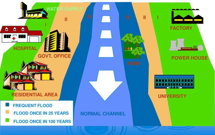
How are Flood Plain Zones classified?
• High-Risk Zone (Zone A) - This zone is closest to the river and has the highest risk of flooding during heavy rain events. In this zone, only limited and essential structures are allowed, such as flood-resistant community centres, parks, and open spaces. Permanent residential or commercial buildings are prohibited to prevent damage and loss of life.
• Moderate-Risk Zone (Zone B) - This zone is located slightly farther from the river and has a moderate risk of flooding. Here, some residential and commercial development is allowed.
• Low-Risk Zone (Zone C) - This zone is situated at a greater distance from the river and has a lower risk of flooding. In this area, most types of development are permitted, including homes, businesses, and recreational facilities.
Significance of Flood Plain Zoning:
• To manage and regulate development in floodprone areas, aiming to minimize damage to property, protect human life, and maintain the ecological functions of the floodplain.
• Zoning helps to manage and reduce the risk of flood-related damage to property, infrastructure, and human lives.
• Zoning ensures that areas most vulnerable to flooding, such as floodways, remain free of development.
NDMA and NGT Guidelines:
• As per guidelines on floodplain zoning by the National Disaster Management Authority, defence installations, industries, and public utilities like hospitals, electricity installations, water supply, telephone exchanges, aerodromes, railway stations, commercial centres, etc. should be located such that they are above the levels corresponding to a 100-year frequency or the maximum observed flood levels.
• According to the National Green Tribunal (NGT), there should be no construction within a 500 m area from the central lining of a river.

Address : 506, 3rd EYE THREE (III), Opp. Induben Khakhrawala, Girish Cold Drink Cross Road, CG Road, Navrangpura, Ahmedabad, 380009.
Mobile : 8469231587 / 9586028957
E-mail: dics.upsc@gmail.com
Address: A-306, The Landmark, Urjanagar-1, Opp. Spicy Street, Kudasan – Por Road, Kudasan, Gandhinagar – 382421
Mobile : 9723832444 / 9723932444
E-mail: dics.gnagar@gmail.com
Address: 2nd Floor, 9 Shivali Society, L&T Circle, opp. Ratri Bazar, Karelibaugh, Vadodara, 390018
Mobile : 9725692037 / 9725692054
E-mail: dics.vadodara@gmail.com
Address: 403, Raj Victoria, Opp. Pal Walkway, Near Galaxy Circle, Pal, Surat-394510
Mobile : 8401031583 / 8401031587
E-mail: dics.surat@gmail.com
Address: 303,305 K 158 Complex Above Magson, Sindhubhavan Road Ahmedabad-380059
Mobile : 9974751177 / 8469231587
E-mail: dicssbr@gmail.com
Address: 57/17, 2nd Floor, Old Rajinder Nagar Market, Bada Bazaar Marg, Delhi-60
Mobile : 9104830862 / 9104830865
E-mail: dics.newdelhi@gmail.com