Ahmedabad
(Head Office)Address : 506, 3rd EYE THREE (III), Opp. Induben Khakhrawala, Girish Cold Drink Cross Road, CG Road, Navrangpura, Ahmedabad, 380009.
Mobile : 8469231587 / 9586028957
Telephone : 079-40098991
E-mail: dics.upsc@gmail.com

Landslide Atlas of India
News: Recently, National Remote Sensing Centre (NRSC) under the Indian Space Research Organisation (ISRO) has released the Landslide Atlas of India, a detailed guide identifying Landslide Hotspots in the country.
NRSC has the mandate for remote sensing satellite data acquisition, processing, archiving, and dissemination to various users.
How was the Atlas prepared?
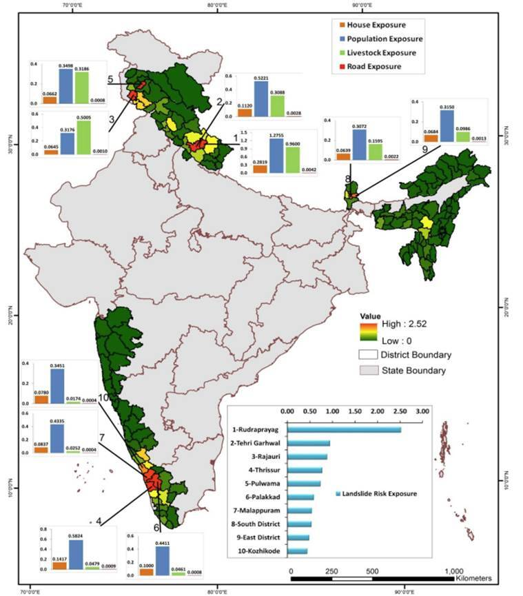
For the first time, scientists did a risk assessment on the basis of 80,000 landslides recorded between 1998 and 2022 in 147 districts in 17 states and two Union Territories to build a 'Landslide Atlas' of the country.
The atlas used satellite data of ISRO to map all seasonal and event-based landslides like the Kedarnath disaster in 2013 and landslides triggered due to the Sikkim earthquake in 2011.
The Pan-India landslide database classifies landslides into – seasonal (2014, 2017 monsoon seasons), eventbased and route-based (2000 – 2017).
Key Findings:
Uttarakhand, Kerala, Jammu and Kashmir, Mizoram, Tripura, Nagaland and Arunachal Pradesh reported the highest number of landslides during 1998 – 2022.
Mizoram topped the list, recording 12,385 landslide events in the past 25 years, of which 8,926 were recorded in 2017 alone. Mizoram is followed by Uttarakhand (11,219) and Kerala.
The number of districts with the maximum landslide exposure are in Arunachal Pradesh (16), Kerala (14), Uttarakhand and Jammu and Kashmir (13 each), Himachal Pradesh, Assam and Maharashtra (11 each), Mizoram (8) and Nagaland (7).
Rudraprayag and Tehri Garhwal districts of Uttarakhand have the highest landslide density and landslide risk exposure in the country.
How vulnerable is India to Landslides?
India is considered among the top five landslide-prone countries globally, where at least one death per 100 sq km is reported in a year due to a landslide event.
Rainfall variability pattern is the single biggest cause for landslides in the country, with the Himalayas and the Western Ghats remaining highly vulnerable.
Excluding snow covered areas, approximately 12.6 % of the country’s geographical land area is prone to landslides. As many as 66.5 % of the landslides are reported from the North-western Himalayas, about 18.8 % from the North-eastern Himalayas, and about 14.7 % from the Western Ghats.
In the Western Ghats, despite fewer events, landslides were found to be making inhabitants significantly vulnerable to fatalities, especially in Kerala.

Address : 506, 3rd EYE THREE (III), Opp. Induben Khakhrawala, Girish Cold Drink Cross Road, CG Road, Navrangpura, Ahmedabad, 380009.
Mobile : 8469231587 / 9586028957
Telephone : 079-40098991
E-mail: dics.upsc@gmail.com
Address: A-306, The Landmark, Urjanagar-1, Opp. Spicy Street, Kudasan – Por Road, Kudasan, Gandhinagar – 382421
Mobile : 9723832444 / 9723932444
E-mail: dics.gnagar@gmail.com
Address: 2nd Floor, 9 Shivali Society, L&T Circle, opp. Ratri Bazar, Karelibaugh, Vadodara, 390018
Mobile : 9725692037 / 9725692054
E-mail: dics.vadodara@gmail.com
Address: 403, Raj Victoria, Opp. Pal Walkway, Near Galaxy Circle, Pal, Surat-394510
Mobile : 8401031583 / 8401031587
E-mail: dics.surat@gmail.com
Address: 303,305 K 158 Complex Above Magson, Sindhubhavan Road Ahmedabad-380059
Mobile : 9974751177 / 8469231587
E-mail: dicssbr@gmail.com
Address: 57/17, 2nd Floor, Old Rajinder Nagar Market, Bada Bazaar Marg, Delhi-60
Mobile : 9104830862 / 9104830865
E-mail: dics.newdelhi@gmail.com